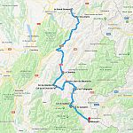
Location:  D526/D926 Le Bourg-d’Oisans to Saint-Jean-de-Maurienne (42 miles)
Coordinates: 45.2294672,6.2114609
Ridden: 2018
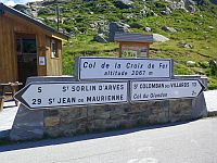
 The Col de la Croix de Fer sits on the D926 between Le Bourg-d’Oisans and Saint-Jean-de-Maurienne, close to the Col du Glandon, and links the Oisans with the Maurienne Valley. It was formally known as Col d’Olle, after the Eau d’Olle river, but owes its current name to the imposing iron cross on its summit.
Starting in Le Bourg-d’Oisans it’s a 10 minute ride up the D1091 to the D526 junction where the southern ramp of the Croix de Fer/Glandon actually begins. For the next 14 miles the pass road follows the Eau d’Olle river up the valley, passing Lac du Verney at the bottom, Lac de Grand Maison about two thirds of the way up, and finally past the restaurant that marks the Glandon junction a couple of miles from the top. It’s great fun to ride with nothing too tight and a reasonable surface all the way up.
At the top of the pass the views over the Arvan Valley, the Aiguilles d’Arves and the peaks of the Massif des Sept Laux are spectacular, and looking down the northern ramp you can clearly see all the villages that make up the Les Sybelles ski resort. It’s a short but steep run down to Saint-Sorlin-d’Arves but from there the road levels out a little, until Saint-Jean-d’Arves where it begins to descend again.
The midpoint is marked by a right turn that takes you to the Col du Mollard, and it’s here that you enter a grey rocky wilderness that continues all the way to Saint-Jean-de-Maurienne. During this time, in a little over 18 miles from the top of the Croix de Fer, you lose an incredible 1,500m of altitude – almost 5,000ft. Epic.
Routes & Posts:

