| Albula Pass |
| Alpe d'Huez |
| Bernina Pass |
| Brenner Pass |
| Bundesstrasse B500 |
| Col Agnel |
| Col d'Allos |
| Col des Aravis |
| Col de l'Arpettaz |
| Col d'Aspin |
| Col d'Aubisque |
| Col du Ballon d'Alsace |
| Col de la Bonette |
| Col du Bonhomme |
| Col de la Cayolle |
| Col des Champs |
| Col de la Colombiere |
| Col de la Croix de Fer |
| Col d'Erroymendi |
| Col de la Forclaz |
| Col du Galibier |
| Col du Glandon |
| Col du Grand St. Bernard |
| Col d'Illoire |
| Col de l'Iseran |
| Col d'Izoard |
| Col de Jougne |
| Col du Lautaret |
| Col de la Madeleine |
| Col de Marie Blanque |
| Col de Mente |
| Col de Meraillet |
| Col de Mont Cenis |
| Col des Montets |
| Col de Montgenevre |
| Col de Montmirat |
| Col des Mosses |
| Col d'Ornon |
| Col du Petit St. Bernard |
| Col de Peyresourde |
| Col du Pilon |
| Col de la Platriere (aka La Casse Deserte) |
| Col de Port |
| Col de Portet d'Aspet |
| Col du Portillon |
| Col du Pourtalet |
| Col de Restefond |
| Col des Saisies |
| Col de la Schlucht |
| Col de la Serreyrede |
| Col du Somport |
| Col du Soulor |
| Col du Telegraphe |
| Col du Tourmalet |
| Col de Vars |
| Coll de Espina |
| Coll de Fadas |
| Colle San Carlo |
| Cormet de Roselend |
| Fluela Pass |
| Forcella Aurine |
| Forcella Staulanza |
| Forcola di Livigno |
| Furka Pass |
| Gerlos Pass |
| Grimsel Pass |
| Grossglockner High Alpine Road |
| Iselsberg Pass |
| Jaufen Pass (aka Passo di Monte Giovo) |
| Julier Pass |
| Klausen Pass |
| Lukmanier Pass (aka Lucomagno) |
| Maddalena Pass (aka Col de Larche) |
| Maloja Pass |
| Mont Aigoual |
| Mont Revard |
| Mont Ventoux |
| Nufenen Pass (aka Passo della Novena) |
| Oberalp Pass |
| Ofen Pass (aka Pass dal Fuorn) |
| Passo dell'Aprica |
| Passo di Campolongo |
| Passo di Cereda |
| Passo Cimabanche |
| Passo di Costalunga (aka Karerpass) |
| Passo Duran |
| Passo d'Eira |
| Passo di Falzarego |
| Passo di Fedaia (aka Marmolada) |
| Passo di Foscagno |
| Passo di Gardena (aka Grodner Joch) |
| Passo di Gavia |
| Passo di Giau |
| Passo di Lavaze |
| Passo Monte Croce (aka Kreuzbergpass) |
| Passo di Mortirolo (aka Passo di Foppa) |
| Passo Nigra (aka Nigerpass) |
| Passo di Pordoi |
| Passo di Pramadiccio |
| Passo di Rolle |
| Passo del San Bernardino |
| Passo di San Pellegrino |
| Passo di Sant'Antonio |
| Passo di Sella |
| Passo dello Stelvio (aka Stilfser Joch) |
| Passo Tre Croci |
| Passo di Valles |
| Passo di Valparola |
| Port de Bales |
| Port de la Bonaigua |
| Port de Canto (aka Coll del Canto) |
| Port d'Envalira |
| Port de Larrau |
| Portillo de Fresno |
| Puerto de Carrales |
| Puerto de Ibaneta (aka Roncevaux Pass) |
| Puerto de Navacerrada |
| Puerto de Palombera |
| Puerto de Paramo de Masa |
| Puerto del Ponton |
| Puerto de la Ragua |
| Puerto de San Glorio |
| Puerto de Tarna |
| Semnoz |
| Simplon Pass |
| Splugen Pass |
| St. Gotthard Pass |
| Susten Pass |
| Timmelsjoch (aka Passo del Rombo) |
| Umbrail Pass |
| Veleta |
| Wolfgang Pass |

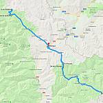
 D5/D205T/SP251 Chateau-Queyras to Casteldelfino (27 miles)
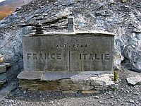
 Col Agnel, or Colle dell’Agnello in Italian, links the Queyras Valley in the Hautes-Alpes, in France, with Pontechianale in the province of Cuneo, in Italy. Despite being the highest international pass of the Alps, and the third highest mountain pass in Europe, it has very little traffic and is somewhat unknown.
